Houston, Harvey and Climate Resilience: A Reflection
By: Elizabeth Wampler, GCC Initiative Officer
Growing up in Houston, I quickly got used to watching the waters rise. I remember Sims Bayou, less than 1000 feet from my house, flooding over its banks multiple times and having to wait out the flooding of my neighborhood streets in drug store parking lots or in unflooded shopping centers having an unplanned dinner out with my family. After some of the very worst storms and longer hurricanes, we would learn that some homes had flooded, but it felt like that was a rarity.
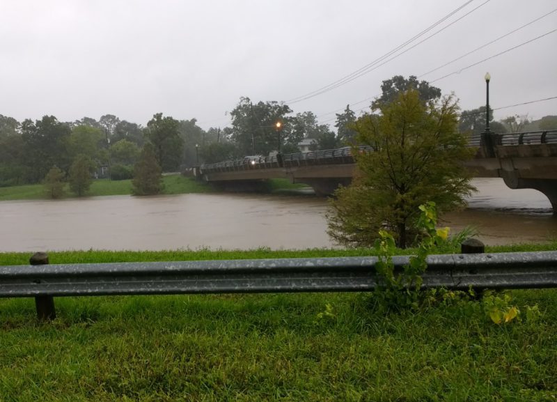
So it wasn’t until stories about Hurricane Harvey flooding homes in the exclusive neighborhood where I went to high school, and reports that 4-5 feet of rainfall were expected, that I began to text my mom twice a day to check on the state of things. While I still don’t understand the how of it, my family got through the storm safe and dry. (Sims Bayou came close, but didn’t flood its banks in Harvey. You can see how high the water is to the bridge that crosses it in the picture below.)
Once the waters from Hurricane Harvey started to recede and I knew my family was safe, I got angry and I got curious. How was it that my neighborhood made it out ok? Was the flooding really worse now than when I was growing up, or was I still relying on childhood naivety and privilege? While I haven’t been able to google an answer to the first question, for the second, there were some really clear theories. In 2016, Pro-Publica and the Texas Tribune published a multi-part piece of reporting that told a story of unchecked sprawl and of flood management leaders who were climate deniers and, somehow, also flood deniers.
Boomtown, Flood Town was written in March 2016 and basically predicted where and how Houston would be flooded in a big storm like Harvey. It was a devastating piece to read as the rain was still falling. There are three key elements that still stick out for me: the massive scale of development in northeast Houston over the last 10-20 years that replaced water-absorbent prairie lands with concrete and buildings (30% loss of wetlands and a 25% increase of impervious surfaces); the head of the Harris County Flood Control District (which covers Houston) who believed there was no connection between the increase in extreme flooding seen in Houston over the last ten years and either climate change or the massive sprawling development; and that those in power held this belief despite overwhelming consensus by scientists and research completed by the flood control district itself.
As an urban planner focused on ensuring that changes to the built environment result in positive outcomes for people – especially low-income people and people of color – this was of course going to be a rage-inducing read. OF COURSE the location of development and infrastructure investment has environmental impacts, and of course those impacts are both deeply local and regional in nature. (Note that where development and investment are located has both local and regional economic impacts, spurring gentrification and displacement in the local, even while meeting regional development goals. See Rick Jacobus’s excellent article for more.)
In the Bay Area, I think, there would be a common consensus around the first idea, that location of development and infrastructure investment has environmental impacts. Through the great work of many environmental advocates and public sector leaders, we’ve repeatedly decided to preserve open spaces and agricultural lands, to make smart environmental decisions about where new development should go which means that when our big floods hit, we are dealing with a different set of causes. And yet, we haven’t been able to get a broad consensus around the other half of that coin – that decisions about where development and infrastructure go also impact people and especially people of color and low-income people.
It’s in how Resilient by Design brings together these two ideas that I get really excited. The project combines the environmental impact question with the people impact question. It not only asks how innovative design can mitigate environmental impact, protecting communities from sea level rise, storm surges, flooding and water contamination, but also, asks how these designs can have the most positive impact for the most vulnerable communities in our region.
This means ensuring that vulnerable communities are engaged in the design process and that their input has real decision-making power and meaning, and it also means thinking outside of the box about what benefit means. In the climate justice space, a question I’ve heard often in hot markets like the Bay Area is ‘who is this work going to benefit?’ As rents rise and low-income and communities of color cannot afford to stay in neighborhoods, the question for a project like Resilient by Design must and does go beyond a question about how to engage community.
How can investments in the implementation of these designs provide a direct economic benefit in good jobs for community members? How can these designs be tied to policies that protect existing residents, ensuring they won’t be displaced just as the new infrastructure improvements mean that future homes will be protected from flooding? These are the fundamental questions that need to be asked and answered to ensure that all people in the Bay Area – especially the communities of color historically shut out from opportunity – can live in safe, affordable communities, where they’re protected from economic and climate-induced displacement.
* Cross posted on Resilient By Design.